Seneca Rocks, Seen From Below
There are places in this state that photograph so often you stop believing they are ordinary ground. Seneca Rocks is one of them. I drove out on the last Tuesday in June to look at it the plain way, from underneath, with no plan more ambitious than walking to the platform and sitting down.
I should say plainly what this day was not. Some people go up the faces of that rock, and I have nothing useful to tell them. My day stayed on the maintained trail and on the valley floor, which is where the long view is anyway.
The drive is the real ask. Charleston to the base of the rocks is 198 miles by the route I take, and the last eighty of those miles are mountain two-lane. Four hours out, four hours back, and you are still ahead if you leave early.
The long way east
I was on the interstate by five-forty and off it at Weston a little after seven. From there the highway runs east through Buckhannon and into Elkins, and the character of the day changes at about that point. Farm bottom gives way to grade, and the speed limit stops being a suggestion you can ignore.
East of Elkins the road climbs over the first big ridge with a truck lane most of the way up. Pavement was new for maybe six miles and then went back to patched blacktop with tar seams that thump under the tires. Fog sat on the top until quarter past eight and burned off in about ten minutes once the sun cleared the ridge behind me.
Through Harman the valley opens, and then the road climbs again, longer and steeper, over the high divide. I came down the east side in second gear behind a hay truck and did not mind it. Where the roads meet at Judy Gap I turned north, and nine miles later the fin came up on the left, all at once, the way it always does.
Standing in the parking area first
The rock reads more clearly before you climb toward it. I was parked by half past nine. I spent twenty-five minutes in the flat area near the visitor center, on the pasture side of the river, just looking up. The formation stands about 900 feet above the water, and from that angle the scale is honest in a way the trail views are not.
What you are looking at is a fin of quartzite. It began as beach sand somewhere around 440 million years ago, hardened into rock, and was later shoved up and tilted until the beds stand nearly on end. The south peak, the notch, the north peak: all of it is that one thin wall seen edge on. In places the wall is not much thicker than a room is wide.
The visitor center at the base lays out the geology better than I can, and the panels reward a slow reading. I stood there long enough to sort out which peak was which, then crossed the footbridge at twenty past ten.
One and three tenths miles of switchbacks
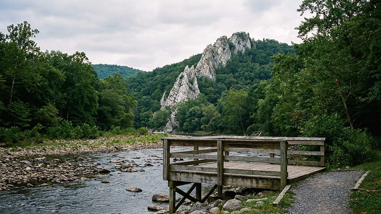
The trail begins with a steel footbridge over the North Fork, which runs shallow and clear over cobbles in June. The bridge is wide, railed on both sides, and flat, so it makes an easy place to stand and watch the water. Below it the river bends south past cut hay fields, and a heron worked the far bank the whole time I was on the bridge.
From the bridge the trail turns uphill and does not stop for one and three tenths miles. Elevation gain is roughly 700 feet, taken in long switchbacks with wooden steps and water bars set into the worst of the grades. The surface is packed gravel and dirt, well maintained, with a few loose sections on the outside of the turns.
I went up in fifty-two minutes with two stops, which is slower than the sign suggests and about right for a warm morning. There are places to rest at most of the switchback corners, and the shade is nearly continuous under oak and pine. Two spots open west across the valley on the way up, and both are worth stopping for even though the platform is better.
The platform, and what the beds do in the light
The trail ends at a wooden observation platform set into the ridge just below the north peak. It is railed, roomy enough for a dozen people, and anchored to the rock. From it you look down the North Fork valley, north toward the far pastures and south toward the gap the river cuts.
Behind the platform the rock goes up in gray and tan bands standing almost vertical. In the middle of the day the beds flatten out and lose their edges, which is exactly the hour I had. Once the haze thinned for a few minutes the seams came back, and every layer stood out separately, like the pages of a book set on end.
I stayed on the platform forty minutes. The wind came steady from the west, cool enough to want sleeves, and the valley below made almost no sound except a tractor working a field two miles off. Vultures rode the updraft at eye level and never once flapped, which I could have watched all day and nearly did.
The descent took thirty-four minutes. Going down is harder on the knees than going up is on the lungs, and the loose gravel on the turns is the reason to take it slow.
The river, and the drive back
I finished the day at the river, on the flat ground near the bridge, with my boots off for twenty minutes. The North Fork there is ankle deep over rounded stone, cold enough to notice, and clear to the bottom. Two families were wading downstream and a man was fishing the seam below the riffle without much conviction.
That is the part of the trip I did not expect to matter. You spend the morning craning your neck at 900 feet of rock, and then the thing you remember is sitting at water level with the fin standing over you.
I left at ten past one and was home by half past five. The mountain grades take longer westbound in the afternoon light, and I lost eleven minutes behind a slow load on the long climb.
What it came to
Twelve hours door to door, 396 miles, and three hours and forty minutes on the ground. Of that, about ninety minutes were spent moving on the trail and the rest was spent standing still and looking, which was the point.
Think twice if a 700-foot climb over one and three tenths miles is more than you want in one push. The valley floor near the visitor center gives you the whole formation without any of the elevation, and honestly it gives you the better sense of scale. Shade on the trail is good, but the parking area and the pasture side have none at all in the middle of the day.
Late June was a reasonable choice and late September would be better. The light in this valley works against you from eleven until two, and it takes until mid-afternoon for the rock to show what it is made of. I drove home before that hour, which is the one thing I would change.
The count
- Time on site 3 hours, 40 minutes
- Driving 8 hours, 20 minutes
- Daylight left 3 hours, 25 minutes
Checked against
- National forest pages for trail distance, elevation gain, and the platform
- The visitor center at the base, for the geology of the formation
- The national weather service forecast pages for Pendleton County
- State highway notices for the mountain grades on the two-lane

Wes CardwellFounder and editor. Charleston, West Virginia. Every trip on this site was driven, walked, and timed by hand.