A Day at Blackwater Falls, Stairs and All
I left Charleston at twenty-five past five with a cold windshield and a thermos filled the night before. Tucker County sits a long way from the Kanawha Valley, and a day at the falls only works if you start in the dark. When I shut the truck door in Davis, the odometer had turned 192 miles. The dashboard clock read nine-twenty.
I have stood at Blackwater Falls twice before, both times in October, along with half the state. Early June is quieter, wetter underfoot, and far greener than the calendar pictures suggest. What I wanted to know was whether the water still runs amber when the leaves are new. It does, and the reason deserves a section of its own.
This is a stairs trip first and a walking trip second. The park keeps a paved path for anyone who would rather skip the long descent. I used both, in that order, then spent the back half of the day working along the canyon rim.
Getting there without hurrying
The first ninety-nine miles are interstate and they are the dullest part of the day. I came off at Weston and picked up the two-lane heading east, which is where the drive actually begins. That road climbs, drops, climbs again, and gives you a truck lane on the worst of the grades.
Between Buckhannon and Elkins the fog sat in the low fields until nearly eight. Pavement was dry, the seams were rough in three or four spots, and the striping had been redone recently. I stopped in Elkins for eleven minutes, stretched my back, and took the north road toward Parsons.
From Parsons the land tilts up in earnest. The last stretch into Thomas and Davis gains something close to a thousand feet, and you hear it in the engine. Davis sits at roughly 3,100 feet and is the highest incorporated town in the state. At nine-twenty in June it was fifty-four degrees, with a wind that had not read the calendar.
214 steps
The park road leaves the highway south of Davis and drops toward the river through spruce and hardwood. It is paved, narrow in two places, and posted low enough that nobody has an excuse. I parked in the falls area at twenty till ten and had the upper railing to myself for six or seven minutes.
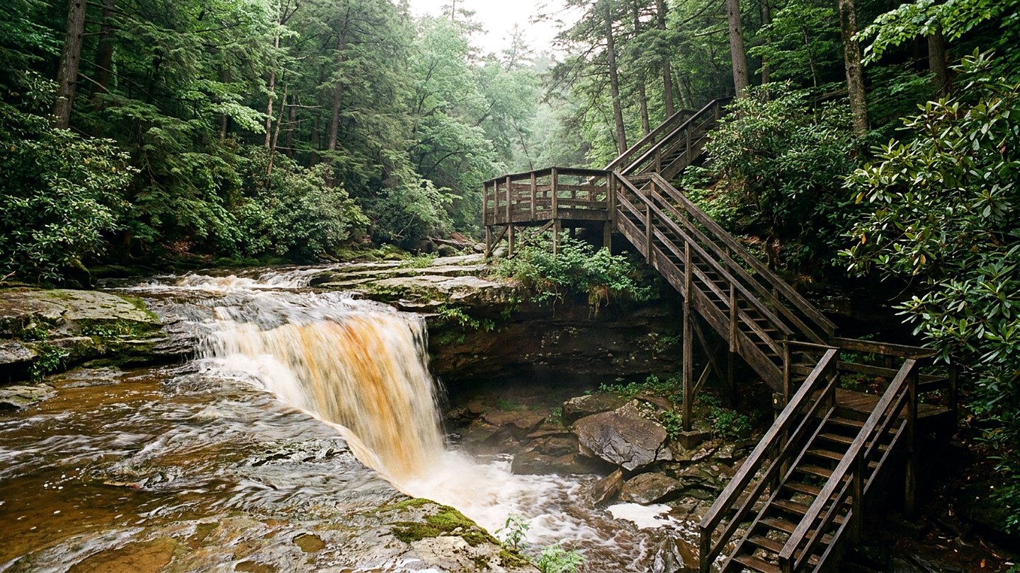
The boardwalk to the main viewing platform is a staircase with landings built into the slope. The park counts 214 steps down, and I counted the same going back up, considerably slower. Treads were wet in the shade and slick where moss had crept to the edge of the wood. The handrail is sound the whole way, and it matters more here than good boots do.
The descent takes four minutes if you push and eleven if you stop at every landing, which you should. Each landing frames the drop a little differently, and the lowest one puts you nearly level with the plunge pool. The falls run about fifty-seven feet from lip to base, over a wide sandstone ledge that has been undercut for a long time. In June the sound is not a roar. It is a steady heavy hiss with a low knock under it where the water lands on stone.
Why the water runs amber
The Blackwater River earns its name honestly, though the name oversells the darkness. The water carries tannic acid leached from fallen red spruce needles, hemlock, and the bogs upstream. In strong light it reads as amber. Held in a cupped hand it looks like weak tea, and over the lip of the falls it turns the color of old copper.
Tan foam gathers at the base in pads that break apart and reform in the eddies. That is organic acid doing ordinary work in a peat-fed watershed, not anything gone wrong. The first time I saw it I assumed otherwise, which is why I mention it.
Light changes the whole business. At ten in the morning the gorge was still in shadow and the water looked brown and flat. By half past twelve the sun had come over the rim, and the same water went the color of a bottle held up to a lamp.
The rim, the paved path, and the canyon
Above and below the falls the river has cut Blackwater Canyon, roughly eight miles long and better than 500 feet deep where it is deepest. You do not see the whole of it at once. You get it in slices, one overlook at a time, and the drive between them is short.
I walked the paved trail first because it is brief and because the view from it is honest. It runs about a quarter mile from a small parking area to a railing set above the gorge. There are no steps on it, the grade is gentle enough for a stroller, and the surface was in good shape apart from two frost cracks near the end.
Then I drove the park road out to its far end and walked to the point that looks straight down the length of the canyon. That is the view I came back for. The far wall is spruce over sandstone, the near wall falls away in ledges, and the river shows as a thin white thread with no sound attached to it.
On the way I stopped at the trailhead for the small falls on the side run near the lodge. That path is short, steep at the bottom, and rooty in a way that punishes inattention. The two little drops there stack one above the other and photograph badly, which I have decided is part of their charm.
Weather, timing, and the drive home
I spent four hours and fifty minutes inside the park and never once felt hurried. The temperature climbed from fifty-four degrees at nine-twenty to seventy-one by two in the afternoon. A shower came through around ten past one and lasted nine minutes, long enough to turn every wooden surface into something that wanted watching.
I left Davis at half past two and was back on the interstate two hours later. The drive home took ten minutes longer than the drive up because of a slow construction stretch near Weston. I pulled into Charleston at twenty-five past six with the light still good over the river and my legs stiff from the stairs.
What it came to
Thirteen hours door to door, 384 miles, and four hours and fifty minutes on the ground. The falls itself asks for twenty of those minutes. Everything else, the rim, the paved path, the canyon overlooks, is what makes the driving make sense.
Think twice if you do not want 214 steps in each direction. The paved path gives you a view without the descent, but it does not give you the depth. Shade is thin in the parking areas and heavy on the stairs, so plan for two different kinds of weather in one day.
In late fall the light leaves that valley early, and by four the canyon overlooks go flat and gray. June hands you room to be slow, and slow is the only way I know to make a drive that long sit right at the end of it.
The count
- Time on site 4 hours, 50 minutes
- Driving 7 hours, 50 minutes
- Daylight left 2 hours, 25 minutes
Checked against
- State park pages for trail names, stair counts, and overlook access
- State park pages for the paved path and its grade
- The national weather service forecast pages for Tucker County
- County road condition notices for the two-lane sections

Wes CardwellFounder and editor. Charleston, West Virginia. Every trip on this site was driven, walked, and timed by hand.